
Here’s a lovely four-mile circular walk around the historical landscape of Glinton and Peakirk

This circular walk starts from the layby on Peakirk Road, Glinton opposite Fox Covert Road. Alternatively you can start in Glinton from the road behind the church or in Peakirk off Rectory Lane. Footpath links are also shown from both Northborough and Etton.
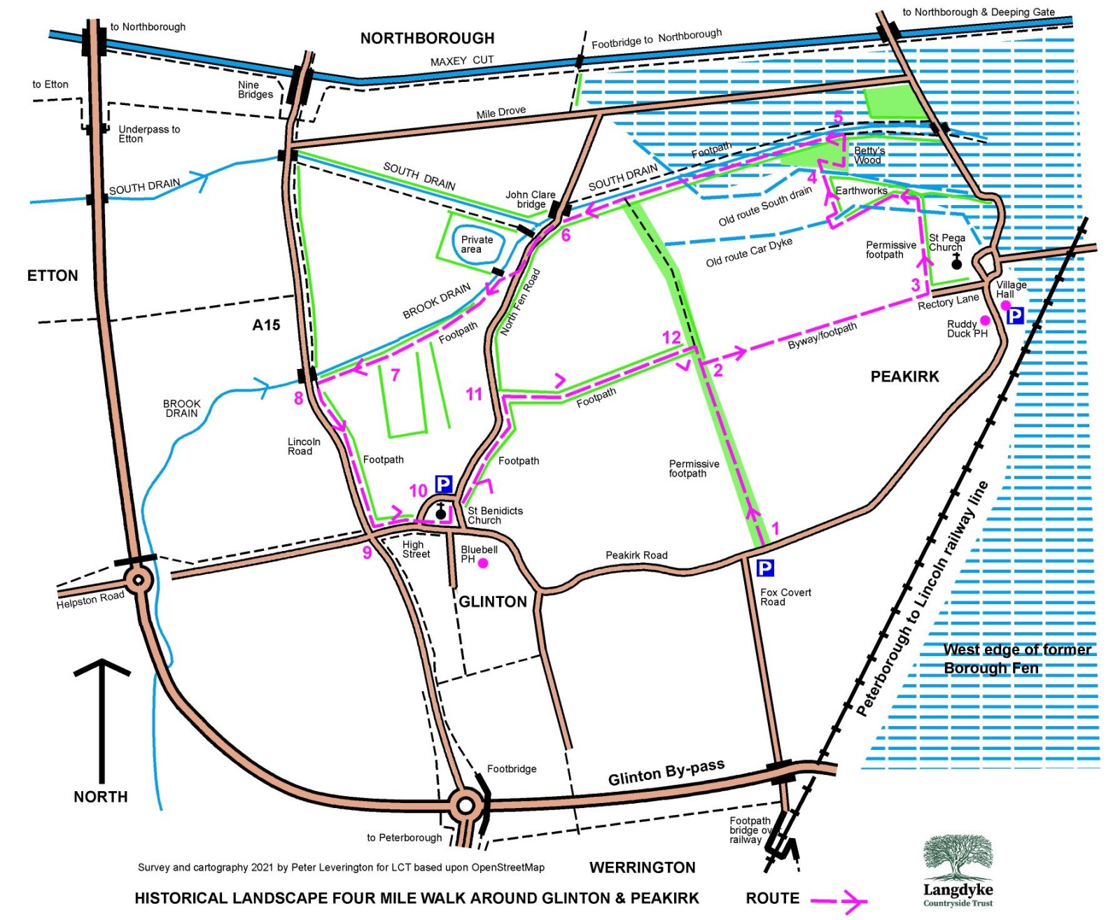
The walk outlined in red, is along old footpaths, often following watercourses, built when the area was wet Fen edge land that bordered on the east side of the long gone Borough Fen.
Conditions started to improve mid 17th century with Fen drainage works planned by the Royal appointed Dutch entrepreneur/engineer Cornelius Vermuyden and funded by speculators then known as the ‘adventurers’.
You will spot in places where watercourses used to meander before later to be straightening. You will also see old ponds now dry and the remains of a past ridge and furrow field system on common land used long ago by Glinton’s villagers to grow their crops.
Route itinerary
1 – Start at the road layby, cross the small wood bridge to walk on the permissive footpath, amongst mature trees from an earlier parish tree planting scheme.
2 – As you emerge from the trees turn right on the concrete pad over the dyke and you are now on an old Byway that linked the churches of Glinton and Peakirk. Before 1856 the villages of Glinton and Peakirk were one Parish.
3 – On reaching Rectory Lane turn left northwards and walk alongside the boundary hedge of what was the old church Rectory. As the path turns westwards, behind the hedge can be seen a remaining stretch of Car Dyke which dates back to Roman times. Look over past Car Dyke to see earthworks from old fishponds stocked by monks as food and income for nearby Peterborough Abbey.
Turn right to cross Car Dyke, here the path bends northwards to an area of trees known as Betty’s Wood.
4 – Planted in 2008 with 750 trees but now mature, the wood is an early nature recovery area created jointly by the residents of Glinton and Peakirk. The land was provided by Mrs Betty Whitton the owner at that time of Glinton Manor. Walking through the area on your right you will clearly see an old route of South Drain before being diverted and straightened n the late 1940’s.
5 -.Climb the steps up the south bank and turn left along South Drain. Originally a 17th century waterway built during the draining and enclosure of the old Borough Fen. To the north are views across the fields to Northborough. Originally common land until changed in the local Enclosure Act of 1819. If lucky you may see Egrets and small flocks of Plovers in the fields or maybe a Marsh Harrier flying overhead.
6 – At North Fen Road look to your right to the stone bridge where Mary Joyce and the local poet John Clare occasionally met after attending Glinton church school. Walk down North Fen road past the bridge over Brook drain. After 100 yards join the signed footpath starting at the private reservoir crossing. Follow this path on the south side of Brook drain.
7 – At this point is an area of a unique landscape with old hedges, narrow strips of overgrown fields and a small area of ancient Willow Trees. Look closely and you should hopefully spot signs of a past meander of Brook Drain close by to two old dry ponds dating back to the time when the fields would have been full of grazing farm livestock.
South westwards across the fields to Glinton you should see in winter conditions the remains of an old ridge and furrow field system. This would have been the hub 200 years ago busy with villagers working on their strips of common land.
8 – As you reach the A15 Glinton to Northborough road, turn left and walk along the roadside footpath towards Glinton.
9 -. Turn left in the village towards the church and go through the gate into the south side of the churchyard.
10 – Opposite the church door is a plum tree, close by is the signed grave of Mary Joyce who features in poetry and prose as the first love of John Clare. Mary Joyce never married and died tragically in a fire whilst still living in Glinton with her sister.
In the past the stone church boundary wall would have been circled by the open space of the village green stretching up to the frontage of the cottages. Go through the church side gate and walk northwards up North Fen Road.
11 -Turn right at the last bungalow, go though the pedestrian gate to walk eastwards along the path. Look right after a while to the back of the 16th century Manor house and its still standing stone dovecot.
12 – Turn right to walk back on the permissive footpath to reach your starting point.